


Basics
- Length:
- 48 miles (77 km)
Description
Vermont's Route 9, the Molly Stark Trail, is named after the wife of New Hampshire's General John Stark who was the victor of the August 16,1777 Battle of Bennington. The Vermont State Legislature named the road the Molly Stark Trail in 1936 to promote both patriotism and tourism. Route 9 is the descendant highway of the road taken by General Stark and his Vermont and New Hampshire troops in the victorious march home after the successful Battle of Bennington, over the forces of King George the III of England.
The Molly Stark Trail winds its way through lowland valleys, historic villages, busy downtowns, and the beautiful Green Mountains.Anchored at either end by the bustling, historic, and cultural centers of Brattleboro and Bennington, the 48-mile Route 9 corridor crosses the heart of southern Vermont.
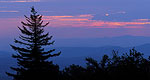
From the rich farmland west of Bennington, to the famous three-state-overlook at Hogback Mountain, to covered bridges, the Molly Stark Trail follows the general footsteps of an old turnpike across the spine of Vermont. The scenic byway rings with legendary Vermont names like General John Stark, Ethan Allen, Robert Frost, and Grandma Moses. It passes famous monuments, unique settlements like Woodford (the highest village in Vermont at 2,215 feet), and important historic districts in Brattleboro, Wilmington, and Bennington.

