


Contact Info
Gifford Pinchot National Forest
10024 US Hwy. 12
PO Box 670
Randle, WA
10024 US Hwy. 12
PO Box 670
Randle, WA
- Phone:
- 360-497-1100
Basics
- Location:
- In the William O. Douglas Wilderness
- Length:
- 3.5 miles
- Elevation Range:
- 4160 feet to 4950 feet
- Elevation Change:
- 790 feet
Description
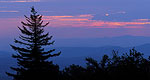
This trail begins from Cowlitz Trail No. 44 and climbs steeply through subalpine landscape to join Judkin Trail No. 47 (at mile 1) which accesses Jug Lake. The trail turns east and climbs to Little Snow Lake and Frying Pan Lake. It ends a short distance past Frying Pan Lake, at the junction with the PCT.
Jug Lake is a 28-acre lake used seasonally as a sheep camp in the early 1900s. The story goes that at certain times the wind blows across the lake in such a manner as to produce a sound similar to what happens when you blow over the mouth of a jug.
Details
Location:
In the William O. Douglas Wilderness
Length:
3.5 miles
Elevation Range:
4160 feet to 4950
Elevation Change:
790

